National Seabed Survey - 2002 Summary Review
Below
is a short summary of 2002 activities in the National Seabed Survey. More
comprehensive information is available by following the links highlighted,
and also through the 2002 News Section.
The seven-year €32 million survey of Ireland's seabed concluded its third year of data collection on the 20th October 2002. The year's surveying had commenced in March following a break of four months during the winter when a much needed break was taken after the long 2001 surveying season.
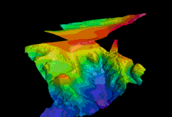 |
In 2002 five vessels and one airplane were involved in carrying out the National Seabed Survey. GOTECH completed Zone 3 in June with the S.V. Bligh and a formal handover of the completed report for the entire Zone 3 area took place in GSI offices in October. |
| In 2002 the Marine Institute was also involved in data collection with its vessel, the Celtic Voyager. After the successful 2001 mini Survey in Galway Bay a similar exercise was initiated in August of this year before she formally commenced Zone 2 surveying later that month. She continued surveying Donegal Bay until October 2002. | 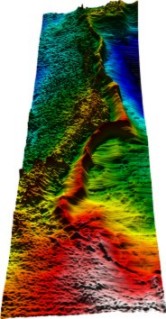 |
A pilot LADS Survey (Laser Airborne Depth Sounder) took place off the Mayo coast at Clew Bay in Zone 1 on June 22-23, 2002. Results of this survey were initially processed in Australia by the contractors, the Tenix LADS Corporation. Quality control checks were then carried out in GSI offices and a formal handover of the data to the Westport Harbour Authority is planned for early 2003. In the meantime, GSI gave the data to the British Admiralty so that they can update the more than 100 year old navigation chart for the area. All parties involved have been impressed with the quality of the data.
| Two further survey programmes were completed in 2002 - the deep seismic HADES programme and the seabed sampling programme. Results from the deep seismic programme will provide a better understanding of the deeper geology of the seabed. In addition, the various features being imaged using the multibeam technique cannot be fully understood and interpreted without groundtruth data. | 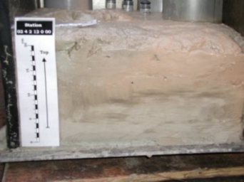 |
Geological ground truthing for seabed classification based on backscatter data is the primary objective of the seabed sampling programme. Geochemical and biological analysis of the samples was also conducted. These survey programmes were carried out by the R/V Akademic Boris Petrov, the S/V Professor Logachev and the R.V. Ocean Seeker. A presentation on the results of the laboratory analysis of the samples will take place in the 2003 Annual Seabed Survey Seminar on November 21.
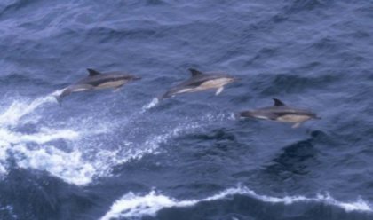 |
Various ancillary projects have also been carried out throughout the period of surveying. Cetacean spotters went out on various vessels including the Bligh and the Petrov. On the latter vessel two CMRC researchers spent a 5-week period onboard as she was carrying out the seismic survey of the western margains of Zone 3 Details can be found here. |