New Seabed Classification Maps Launched - July 2004
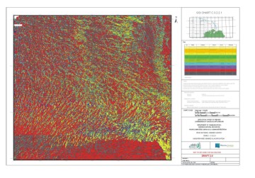 |
GSI, in collaboration with MI, is currently producing on-line seabed classification maps (1:60,000) for the entire Zone 1 & 2 areas on the Celtic Explorer.These maps represent a classification of the entire seabed into different geological types from fine sediments (sands) to coarser clastics (gravels) and exposed bedrock. The Image provincing involved is based on the acoustic reflectivity of the sonar. These are final products developed from INSS data. |
These products can then be used as a baseline dataset for different applications such as marine habitat maps, fisheries maps (leading to improved efficiency and conservation), marine sand/gravel extraction, marine cable planning and others. The processing of these maps has been developed in close partnership with Quester Tangent Corporation and the University of Victoria in Vancouver Island, BC, Canada.
Announcement of Workshop in GSI
INSS's work on Seabed Classification is breaking new ground and various international organisations are now seeking to learn from the Irish experience. To this end GSI and Quester Tangent Corp. are hosting a workshop in Seabed Classification on 25th & 26th January 2005. The purpose of this workshop is both to provide a theoretical background and 'hands-on' experience to the QTC approach for seabed classification. Particular emphasis will be placed on data QA and production processing techniques. Techniques for post-processing, mapping and visualization will also be presented and widely discussed. Single-beam, multibeam and sidescan sonar data will be analysed, processed and the results exported during the tutorial. Full working versions of the software will be loaded onto participants PC's, experimentation with data processing is encouraged. Participants will be provided with data and 30-day licenses for data analysis following the workshop. For a full programme and registration details please contact Xavier Monteys (by e-mail) or ++353 1 678 2807