News 2001 and before
- Annual Seabed Survey Seminar, 16 November 2001
- Marine Institute Survey in Galway Bay
- Laser Airborne Survey postponed - September 2001
- Siren completes its surveying trip this year - 24 September 2001
- Minister announces Survey ahead of schedule - 20 July 2001
- Promotion of the Survey to a British Audience - 17 July 2001
- CORDIS hosts a revamped service dedicated to Ireland - July 2001
- DTI announces publication of the SEA2 Draft Assessment Document - September 2001
- Seabed Survey Launch - 14 July 2000 - Press Release
Marine Institute Survey in Galway Bay
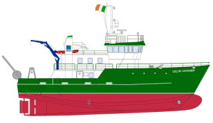
The Marine Institute conducted a seabed survey in Galway Bay using the R.V. Celtic Voyager, during August and September 2001. In essence the survey was a prelude to 2002's Zone 2 data acquisition. The project was on-going until the end of the 2001. Some of the initial unprocessed multibeam images from the survey indicated an extremely complex seabed morphology. Areas covered by the survey include those of hydrographic, geological and fisheries interest.
 |
The project involved:
|
The Marine Institute team continues to work on the project with survey contractors Global Ocean Technologies (GOTECH) Ltd as well as Canadian experts funded by the Irish Newfoundland Partnership.
LADS (Laser Airborne Depth Sounding) Survey Postponed
|
The LADS survey off the South East Coast was scheduled for September 24th, 2001, but unfortunately it had to be postponed until 2002. LADS is an internationally accepted survey tool which is accurate to IHO standards. With speeds of up to 65 sqkm/hour it is the fastest, most cost-effective tool for accurate survey in of the entire seabed area at depths of 70m in clear waters. It can be efficiently Integrated with operations of various survey ships. It has the added benefit of being environmentally friendly. It produces nautical charts for safe, efficient shipping, provides EEZ delimitation and mapping. Results are also useful for coastal zone and coral reef mapping and management, marine exploration, engineering and marine resource management.
|
 |
Siren completes its 2001 surveying season
 |
On 24 September the Siren demobilised for the final time of the 2001 surveying season at the end of her 6th leg away at sea. She largely concentrated her operations in depths of between 200m and 500m during the season. She finished up in Zone 3, Area 3E where she completed her allocation of 17% of that area (the remainder was completed by the Bligh). Altogether she was at sea for almost 24 weeks this year. |
Minister announces Seabed Survey ahead of schedule - 20 July, 2001
| The Minister of State at the Department of Public Enterprise, Mr. Joe Jacob, TD., announced today (20 July, 2001) that the National Seabed Survey is achieving high quality results and is proceeding ahead of schedule. The Minister was visiting the survey vessel Bligh during the course of its visit to Galway Docks. Minister Jacob stated: "This survey will prove invaluable in the future. The survey is achieving high quality results and is ahead of schedule." |  |
"I am pleased that the data is being produced by a partnership of Irish skills, from both the public and private sectors. Gotech Ltd., is a world-class leader in this type of surveying and this project is a showcase for its expertise and capability. Their success should assist in developing the export market for Irish and marine skills in the years ahead." "We are now recognised internationally as having an excellent maritime database in preparation, backed by Irish expertise of a very high quality. The results of the survey will be important in terms of our environment, economy and scientific knowledge," the Minister said.
The Minister went on: "This survey has thrown up many interesting results. For example we now know that the occurrence of deep-water corals is more extensive than we believed and their distribution is now known in some detail. These corals represent delicate ecosystems of international importance. They are also important as fish habitats and the survey results will provide invaluable information which will ensure that fishing can be undertaken efficiently and with minimum impact on our marine environment." "Another interesting feature is the mapping of a major landslide in the north-west margin of the Rockhall Trough. We had known about it but the survey has accurately delineated its extent. Earthquakes would have triggered this. The results will enable us to understand better the range of environmental hazards on the Irish seabed. This is particularly important for activities such as oil and gas production and cable laying," the Minister added.
Promotion of the Survey to a British Audience - Information Seminar in London
On July 17th 2001 the G.S.I. held an information seminar about the National Seabed Survey in Reading, at Madjeski Stadium,the grounds of the London Irish Rugby Club! The objective was to make key potential customer groupings aware of the survey and the very interesting data that is resulting from it. It is hoped that some of those present will become purchasers of the same data in the near future. The seminar discussed and displayed the data acquisition processes and the maps and datasets resulting from the various surveying techniques.
It
encompassed speakers from G.S.I., GOTECH (the surveying company used for
Zone 3 data acquisition 200m-4500m), Kongsberg
Simrad (whose EM120 and EM1002 are the primary multibeam data acquisition
tools) and Caris, whose
software is the primary processing software. Thus we showed the full range
of operations within the survey so as to instill confidence in the results
being produced. Those in attendance included senior representatives from
leading companies within our various target markets, including, cable-laying
and telecommunications companies, marine surveying companies, marine data
brokers, academia and exploration companies. There were 25 attendees who
were treated to lunch at the end of the full morning session. Feedback
on our presentation was excellent, so much so that we are now thinking
of a further seminar in another big base in the marine world, Aberdeen.
CORDIS hosts a revamped service dedicated to Ireland
eCORDIS, the European Commission's Research and Development Information Service is now hosting a revamped service dedicated to Ireland. Developed jointly by CORDIS and the Office of Science & Technology in Dublin, the service provides a window on Irish innovation-related infrastructures, services and activities. Users can locate a number of national and local organisations offering assistance and advice to companies and researchers. In addition, the site offers in-depth coverage of Ireland's participation in the Fourth and Fifth framework programmes as well as results from these projects.
Close-ups on successful developments are highlighted in the "Spotlights" section. Detailed information on Irish co-operation with other Member-States is provided, as are national contributions to the current discussions on the next Framework programme. A search facility allows users to access contact details of previous project coordinators and partners. Key events and news reports are accessible to keep track of both the National Development Plan and European activities. Users are encouraged to contribute their own comments on European developments.
The site will prove useful for local stakeholders and innovation actors seeking technology information and partners in Ireland. The service is part of a gateway project aiming to offer access to R&D information in each Member State and to support the completion of the European Research Area (ERA). For further information see the Irish or Member State homepages of the CORDIS site.
DTI announces publication of the SEA2 Draft Assessment Document
On 12 September 2001 the UK Department of Trade & Industry (DTI) published its Strategic Environmental Assessment document for mature areas of the North Sea known as SEA2. The purpose of this document is to make a regional assessment of the environmental implications of future Oil & Gas licensing in the SEA2 areas. There will now be a formal consultation period of 90 days during which time the general public are invited to review and comment upon that assessment. On the 10 December the consultation period will close. The mature areas of the North Sea have been developed for oil and gas production over the past three decades and thus already have been extensively studied. To develop further understanding, the DTI commissioned surveying and sampling work in 2001 to examine features such as pockmarks and sandbanks, preliminary results of which are reported upon in parts of SEA2. SEA2 is part of the DTI's general plan to complete a strategic environmental assessment of the entire UK Continental Shelf. For further information please see their website.
Minister
announces £21m Seabed Survey:
Press Release - Howth Yacht Club, 15 July, 2000
|
Ireland is an island nation, but it is only in more recent times that we have begun to realise the extent of our marine heritage. Yet we still know little about our seabed - its nature, its environment and its resources. According to Minister Jacob "this is an ambitious survey that seeks to map the entire extent of our seabed area. When you realise this area is ten times that of our land area then the extent of the challenge becomes evident." |
 |
In authorising this survey the government has recognised that Ireland must maximise the commercial opportunities presented by its marine resources and plan measures to protect the marine environment in the most effective manner possible. Results of the survey will be used to support policy development concerning Ireland's marine resources, as well as to stimulate their sustainable management and development. Mr Jacob pointed out that the survey "will complement the national strategy for marine research, technology, development and innovation as developed by the Marine Institute."
Additionally, the survey will lead to an increased pool of marine specialists and an international shop window for Irish marine expertise and technologies. Indeed Mr Jacob is delighted to announce that the main contract for data acquisition has been awarded to an Irish contractor - Global Ocean Technologies, who beat off fierce international competition. Furthermore, the Minister announced a number of technical measures designed to strengthen Ireland's skills base in marine science and technology.
A number of vessels will be employed to carry out the Seabed Survey. These vessels will cruise back and forth across the Irish seabed area carrying a variety of instruments which will measure the characteristics of the seabed and its underlying rocks. The main technique used will be multibeam echosounding, a variety of the technique used by fishermen to explore for fish. Interpretation of the data retrieved will give us clues to the commercial usefulness of our seas and seabed. The resulting maps will be used by a wide variety of interests including policy-makers, fishermen, engineers, biologists, oceanographers and geologists. Products will be made available in both paper and digital format.