Ray Keary is honoured - 25 April 2002
On Thursday May 9 Lorna Siggins, Marine Correspondant Irish Times, in her column writes that "the work of an unsung hero of Irish marine science, Dr Ray Keary, is recognised at last." She goes on to comment that the geologist "Dr Ray Keary found himself in some distinguished company late last month when he joined the SDLP's Seamus Mallon, trade unionist Peter Cassells and European Parliament president, Pat Cox, in Dublin Castle. The occasion was the conferring of honorary degrees (DSc for Ray) by the National University of Ireland, and Mallon, Cox et al should have felt similarly overawed at being in the company of the scientist, who is best known for his work with the Geological Survey of Ireland (GSI). It is largely thanks to Keary that Ireland's extensive seabed territory - measuring 10 times the size of this island - is being mapped by a multi-disciplinary team involving the GSI and the Marine Institute at a cost of €27 million. That accomplishment represents just a small part of his contribution to marine science."
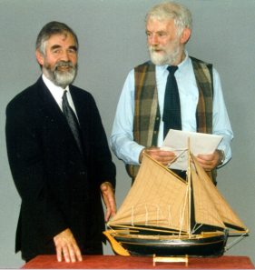 |
Dr Keary, pictured here with Dr. Peadar McArdle, Director GSI, on the occasion of his retirement from GSI in 1999, had seen water, both onshore and offshore, as a constant right throughout his life. He grew up in a small village, Woodford, near Lough Derg in South East Galway. He remembered that his Grandfather "always had a boat out on the lake" and that he taught him how to row when he was scarcely big enough to even handle the oars! Water too played a role in his father's life as, before Ray was born, his father was the doctor to the island of Inishbofin. Ray headed off to UCD as a teenager to study for a BSc and continued his studies via post-graduate research into the Wicklow Granite. In 1962 he was appointed as Assistant Junior Lecturer in UCG. Later in his career he went on to complete an MSc in Oceanography. |
Back in the 60's a lot of British universities used to carry out research in Connemara. As he quickly realised that it was almost impossible to compete with their equipment and resources, it was a natural deviation for Ray to begin to concentrate his research activity on the seashore, or as Ray himself put it "to begin rooting around on the seashore!" Thus began his odyssey into marine research commencing with several papers on the composition of beach sands. He managed to convince Prof. Mitchell, an Engineer Geologist, the then Head of the Department of Geology, to introduce marine geology to the BSc course. Until then geological maps reached the shoreline and "only a blue boundary appeared thereafter, so did the geology stop there?" he often wondered!
Because of his ever-increasing interest in marine geology and the dearth of like-minded scientists, Ray availed of the opportunity to go out to sea on several ships one of the first being the Prince Madog of Wales. One of her cruises showed for the first time prospectivity on the Porcupine. As a Junior member of the teaching staff Ray tried to encourage an interest in marine science and he credited Prof. Mitchell with a great degree of "tolerance" as he let Ray pursue what was by now his main scientific interest. Also helpful was the fact that the Zoology Department in the college was also involved in marine work and there was real co-operation between both departments. In the earlier cruises the data collection methods included sampling equipment, "sparkers" for shallow seismic data and the Kelvin Hughes Transit Sonar for side-scan sonar data. In the case of the sparkers two were strapped together and two sets of bang boxes were used.
Ray had many extra-curricular activities during his time in Galway. Perhaps not known to too many is the fact that he used to run guided tours of Galway's building heritage. The tours took place on a Saturday afternoon, and oddly enough many of the buildings visited lay adjacent to some well-known watering holes!
As the emphasis on marine science slowly began to improve UCG acquired a small boat the Ona III and Ray began taking students out on it. One particular day whilst dredging west of the Aran Islands it was dead calm. At sea on a calm day mist can play tricks with the eyes and it certainly did to one of the students that day - a very well known "character" who holds distinguished office in Irish Marine Science today. For as Ray recounted the story to me this government official indeed claimed full sight of that great island, Hybrasil, that very day! Ray was appointed Statutory Lecturer in UCG in 1970 around the same time that Prof Mitchell retired and a few years after Dr.Williams became Director of GSI. The latter appointment was significant since Dr. Williams had been involved in Marine Geology in New Guinea. Dr. Williams agreed to set up a Marine Section in GSI if Ray would come on board (ahem!) and so Ray did in 1975. Times were good in the early seventies with the economy in good shape and in 1975 the National Science Council bought the Lough Beltra in Killybegs. She was the first Irish research vessel. Despite Ray's preference for Western waters she began work in the Irish Sea since the demand here was greater than off the west coast, with gravel banks being of particular interest. During her initial cruises the equipment used included sparkers, boomers, side-scan sonar (a little later) and, because of a link with Prof. Tom Murphy and the Dublin Institute for Advanced Studies (DIAS), magnetometers.
Then in the late '70s the economy hit some hard times and the GSI Marine section was whittled down to just Ray himself as other temporary colleagues moved onwards. This time was characterised by a link with the British Geological Survey and a series of corroborative maps, mainly for the Irish Sea, was produced. In 1979 BIM asked for a piece of work to be done off the Donegal coast and this turned out to be very significant indeed as it was the first applied work that had been requested in the marine field. The situation was that there were two patches of clear ground for trawling but they lay separate, and trawling each on its own was uneconomic. It was decided to use side-scan sonar techniques to locate a clear path between the two. This was done very successfully and a GSI Report was published in 1980 entitled "RS 80/1 Marine Geology, Identification of potential trawling-ground by side-scan sonar." Co-operation with DIAS on this project also produced some very interesting magnetics data. By now Ray was espousing the view to all who would listen "provide the service and the market will come." Unfortunately though the economic climate wasn't improving much and the Beltra was taken out of service for a year due to insufficient funds.
 |
Around this time, over a pub conversation (where else?!) with Captain Frank Traynor, skipper of the Beltra and 2nd Captain of the Asgard II, Ray had the brainwave of using the Asgard II as a test case for research. The Asgard herself as an almost totally manual ship was not really appropriate for surveying but her size was about right and using her would give one an idea of what kind of a schooner was best suited to research. So, very optimistically, Ray put a proposal to his department to hire the Asgard II for a few weeks. Miraculously for the economically stagnant time, the proposal was approved and Ray gathered together a mix of scientists for the experiment. Despite dreadful weather conditions the experiment was a success, "she could hold a steady course and she was much more sea-friendly than the Beltra." Despite the relative lack of sea-friendliness of the Beltra, Ray's memories of the Beltra are mostly good ones, but there was one notable exception - he broke his leg in Galway getting back onto her after seeing a movie downtown! To this day a piece of metal holds his left leg together after the break.
|
Also, around this time the UN Law of the Sea was in progress with Piers Gardiner to the forefront of the quest to define our boundary - the Irish/Gardiner formula. Similarly, Ray recalls that Dr. Williams was summonsed to the Department of Foreign Affairs to draw a line for the boundary. Ray relates that Dr. Williams did a fine job considering what we now know compared to what he knew then. Then, the boundary definition aspect of marine responsibilities was taken from GSI and given to the Petroleum Affairs Division (PAD) who then proceeded to do some work around the boundary line.
Never one to capitulate easily however Ray "continued to agitate" about the need to survey our entire seabed area (10 times the size of our land area). Finally, the current GSI Director, Peadar McArdle, reacted to the ongoing agitation by politely requesting a plan and a cost figure! Ray duly obliged, estimating a cost of Ł10m which proved later to be quite accurate indeed for its time. Then another significant event occurred - the GLORIA survey. GLORIA was a long range mapping device and GSI, through Ray, got money from the Marine Institute to use the technology and the survey proved successful in that it showed that GSI could run a big marine Survey.
| By now, Dr McArdle was fully convinced that, as Ray had argued for years, the entire seabed area should be surveyed and a formal proposal was submitted to government. Then, in April 1999 the Government approved a £21m survey of the Irish Seabed. A short time later Ray Keary retired, content that his career dream had finally been realised. Today the seven year survey is delivering high quality data and is a testament to his outstanding dedication to marine science. |  |
Throughout his career Ray was tremendously supportive of all aspects of marine science. He consistently and selflessly gave of his time and energies to assist a plethora of academics and others involved in the marine world. Well past his retirement he was still assisting old colleagues in GSI, we will miss him greatly. Ray Keary RIP.
Enda Gallagher