Web Mapping
GSI Web Mapping: Access Here. Read on for information on how to use it.
Data
Request Potential
data users must fill in an application form.
This project is a G.S.I.-wide project being undertaken, under the Information Management Programme, to put G.S.I. maps on the web. The initiative has evolved from a number of areas, including our Geotechnical database GIS project and the CONOR - database project. Essentially we are using proprietary Web Mapping software (ESRI's ArcIMS©) to place GIS-(Geographic Information System) enabled maps on a web-accessible server.
|
|
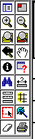
The
toolbar on the web mapping site allows you to do many of the
basic operations you would carry out in GIS. These are from top
left, top right etc.: |
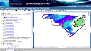 |
The viewer controls the map image he or she sees by selecting which layers to make Visible (can be seen) and which to make Active (i.e can be queried or features identified). These are switched on or off in the aradio buttons opposite the layer names in the right-hand men One of the most useful features is the ability to construct queries, based on attributes of the tables on which the maps are built e.g. querying all the characteristics of a selected rectangle, or highlighting on the map a given feature. Once selected these features can be "zoomed to" from the hyperlinks returned with the query. |
The majority of this work is being carried out by Archie Donovan, the Seabed Survey Data Manager, with help from Koen Verbruggen (Information Management Programme) and Shane Tyrrell (Bedrock Programme). The site is a Beta site very much at the development stage and subject to ongoing testing. Additional maps will be added as time goes on and we welcome your feedback on the site, maps and attribution, to Archie or Koen. Please have patience as the initial aplet takes a while to load depending on your connection speed, averaging 45secs on a 52k modem. Querying the data is also quicker than zooming or panning.
The link below will bring you to the site, just backbar to return. The actual IP address of the site is https://www.gsi.ie/Mapping.htm Enjoy (you can't break it!)